...Venezia...Ludovico Ughi. 1739.
...Venezia...Ludovico Ughi. 1739.
Couldn't load pickup availability
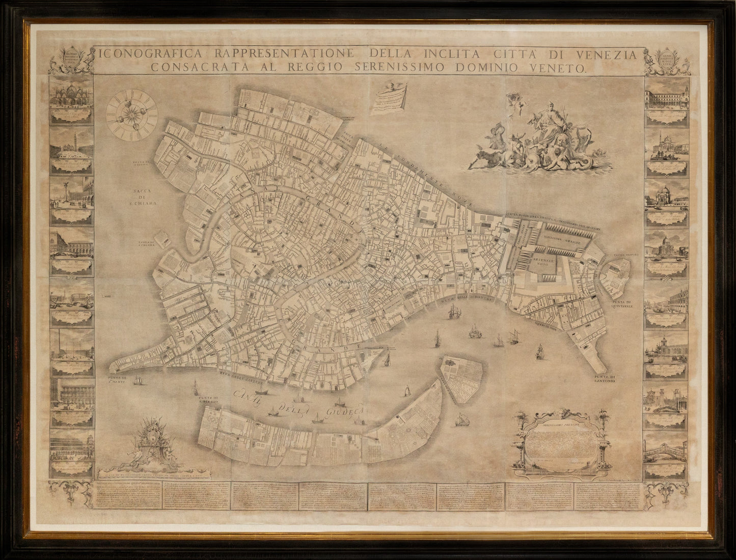
UGHI, Ludovico (Active c. 1700-1740).
Iconografica rappresentazione della inclita città di Venezia consacrata al reggio serenissimo domino veneto.
Engraved map.
Venice: 1703 (Second State, 1739).
74” x 83” sheet, 82” x 91” framed.
Large engraved wall map joined, with additional panels bearing the running title at head and side panels containing 16 views of prominent buildings (engravings attributed to Francesco Zucchi, after Luca Carlevarij's 'Fabriche e Vedute di Venetia', 1703), coat-of-arms surrounded by putti and military equipment of Francesco Morosini (1619-1694, last of the 'warrior Doges') to lower left, lion of Saint Mark surrounded by marine creatures (after a drawing by Sebastiano Ricci) to upper left, cartouche at bottom right with dedication by Ughi to Doge Alvise III Mocenigo, descriptive text along the lower border.
Apparently the second edition with the imprint of Lodovico Furlanetto. This plan was the first of Venice based on an accurate field survey, with its size allowing for considerable detail, and served as the prototype for all plans of Venice almost to the end of the century.
Lodovico Ughi's topographical map of Venice is a landmark in the carto-
graphic history of Venice. It was printed from twenty copper plates on thir-
teen sheets, and is flanked by sixteen views of Venice. The Ughi map is the
first and still largest topographical map produced of Venice based on accu-
rate field surveys rather than on observation and copying of existing maps.
Republished twice again during the century,it became the basis of all later
topographical representations of the city, down to the fall of the Republic
in 1797. Through its copies and subcopies, it dominated the field of
Venetian map making well into the nineteenth century.
Over the centuries, Venetian map makers in general copied one another
and did not significantly alter the appearance of the city from year to year.
Among the exceptions are Jacopo de Barbari's magnificent bird's eye view
of Venice printed in 1500 and Ughi's map of 1729. Not only are they the
two the largest printed maps of Venice, but they served for centuries as
models for all subsequent plans made of the city.
The bird's eye view depicted a city from a high oblique angle, enabling the
cartographer to convey the vertical dimension of the buildings and archi-
tectural features of the city, while at the same time retaining a horizontal
dimension, which relied on perspective rather than true scale. The inten-
tion was to impress the viewer. The advancements in science and technol-
ogy in the eighteenth century improved the surveying and measuring tech-
niques used by urban cartographers who produced works progressively
more accurate and functional. By the 1730's bird's eye views no longer
matched the standards of accuracy expected of urban surveyors who were
now commonly depicting towns by means of a less decorative but more pre-
cise ground plan, the topographical map.
At the time of the printing of the Ughi map, Venice had been an independ-
ent republic for almost 1000 years during much of which she had been mis-
tress of the Mediterranean, the principal cross roads between East and
West, and the richest and most prosperous commercial center in the civi-
lized world. The Ughi map is nothing less than an advertisement for the
beauty, military might, and prosperousness of Venice. The title itself
announces it: "Iconografica Reppresentazione della Inclita Citta` di
Venezia al Reggio Serenissimo Domino Veneto" (Topographical
Representation of the Glorious City of Venice Consecrated in the Reign of
the Most Serene Veneto Domaine). Flanking the map portion eight on
each side, are sixteen beautiful views of the city of Venice. Views of the city
were included because the new planographic type of map now lacks the
famous landmarks, attractions, and depictions of fortifications of the bird's
eye view maps (beauty, affluence, and military might).
At the bottom left around the shield of the Morosini are seen putti hold-
ing, flags, pikes, and staffs - triumphal war articles. Francesco Morosini, the
last of the warrior Doges, led the battle against the Turks in the War for
Candia or Crete which was lost to the Venetians after 465 years of occupa-
tion in 1669. This symbol would not have been lost on Europeans of the
time. The siege of Candia lasted for twenty-two years in which the
Venetians, though from time to time aided by European allies, stood alone
in the defence of the town and the encroachment of the Turks into
Western Europe. At top right is the depiction of an allegorical Venice, tri-
umphantly sailing on the sea pulled by dolphins, sea animals, and divini-
ties, with the lion of St. Mark at her feet, symbolizing her marriage to the
Queen of the sea and the riches she derives from it. St. Mark is the patron
saint of Venice. At the top left of the map, is the Vitruvian windrose, each
wind direction personified by the head of a putti, and the eight major
points of the compass, important for a city dependent on seafaring trade.
In the cartouche at the bottom right, is a dedication by Lodovico Ughi to
Alvise Mocenigo, the Doge in 1729. He expounds on '...the glorious city of
Venice, blessed by the Virgin, divine, Queen of the Adriatic, always envied,
a constant sustainer of the Catholic religion, known throughout the world
for her justice, feared by her enemies, defended in all times by her sons who
have sacrificed their lives, ..., your most humble servant Calviai. Lodovico
Ughi.'
Because of the large scale of the map, for the first time place names are
directly on the map, rather than using reference letters or numbers corre-
lating to a text below. To distinguish urban elements, the streets are depict-
ed with parallel lines, the religious buildings have closer parallel lines and
letters, and the rios and canals are shown by wavy lines. The civic buildings
are left in white.
The importance of the printed Ughi map in eighteenth century Venetian
culture cannot be underestimated. The publishers, engravers, and artists
involved in its creation were some of the most talented and prolific of their
time. Though not conclusive, stylistic evidence points to the hand of
Francesco Zucchi as the engraver of the sixteen views of Venice which flank
the Ughi map. Zucchi, a member of Baroni's guild, was a prolific book
illustrator. The prints of the views, more refined, are directly copied from
Luca Carlevarij's, famous Fabriche e Vedute di Venetia, published in 1703.
Carlevarij was one of the famed Venetian "vedutisti" or view painters.
Recent studies have uncovered a drawing of Venezia Trionfonte by
Sebastiano Ricci (1659-1734), an acclaimed Venetian painter, that can now
be established as the preparatory drawing for the allegorical figures in the
upper right of the Ughi map. The drawing is in album #56 from the library
collection of Anton Maria Zanetti (Academia Gallery,Venice), a friend and
patron of Sebastiano and Marco Ricci.
SIXTEEN
VIEWS:
Left Side
- Veduta della Chiesa Ducale di S. Marco
- Veduta della Piazza di S. Marco versola Chiesa Ducale
- Veduta della Piazzetta verso la Lecca
- Veduta delle Prigioni architettura Sansovino
- Veduta della Piazza di S. Marco dalla parte del mare
- Veduta della Piazza di S. Marco verso S. Geminiano
- Produrative nove architettura di Vincenzo Scamozzio
- Procurative vecchie architettura di Mastro Bono Proto di S. Marco
Right Side
- Veduta della Piazza di Rialto
- Chiesa di S. Giorgio Maggiore Architet.ra di Andrea Palladio
- Chiesa del Redentore Archi.ra di Andrea Palladio
- Chiesa di S. Maria della Salute Architet.ra di Baldisera Longhena
- La Lecca sopra la Pescaria Architettura Sansovino
- Veduta della Dogana da Mare Architettura di Guiseppe Beloni
- Veduta esteriore delle Porte dell Arsenale
- Veduta del Ponte di Rialto Architet.ra di Antonio dal Ponte