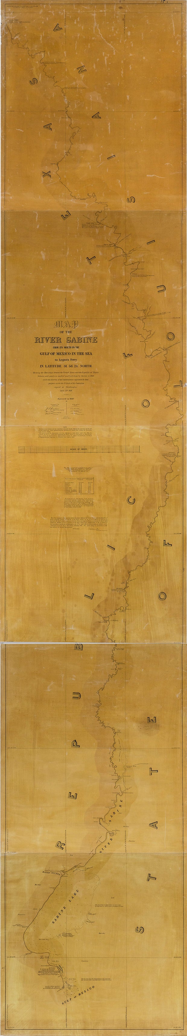
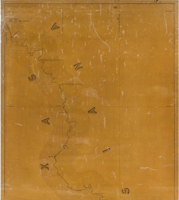
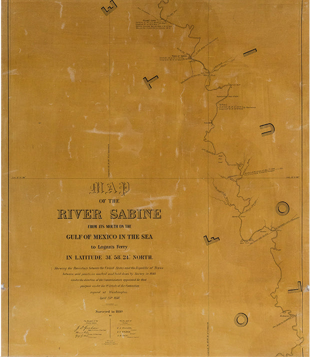
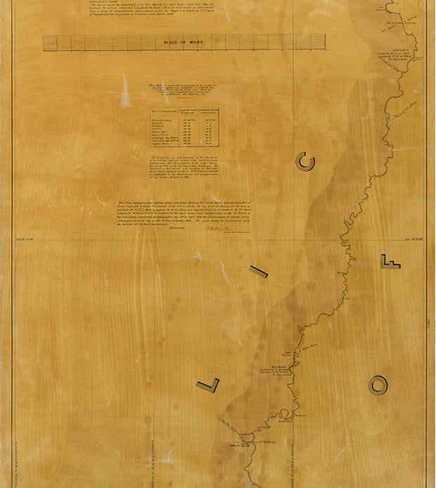
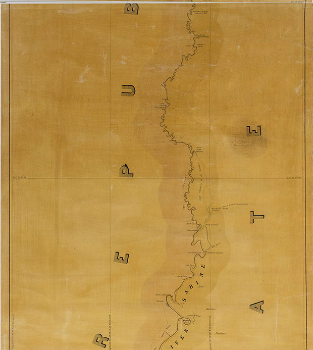
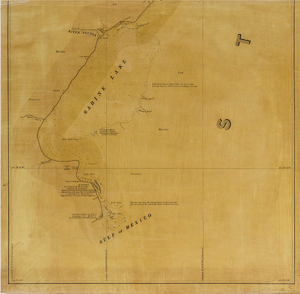
Lee, T.J. Map of the River Sabine from its mouth on the Gulf of Mexico in the Sea to Logan's Ferry. 1838
Lee, T.J. Map of the River Sabine from its mouth on the Gulf of Mexico in the Sea to Logan's Ferry. 1838
Couldn't load pickup availability
THE MAP USED BY TEXAS & THE UNITED STATES TO SETTLE THE REPUBLIC’S EASTERN BOUNDARY
Drawn by Lieut. T. J. Lee, U.S. Topographical Engineers
Map of the River Sabine from its Mouth on the Gulf of Mexico in the Sea to Logan's Ferry Lithograph
Overall size: 2'4" x 14' (in five sections)
Issued by the United States and Texas Joint Commission for Marking Boundary
Certificate of correctness signed by U.S. Commissioner J. Overton Washington D.C., 1842
References: T. W. Streeter, Bibliography of Texas, 1795-1845 (Cambridge,
1955-60), 1439 and p. 239; and J. C. Martin & R. S. Martin, Maps of Texas
and the Southwest, 1513-1900 (Albuquerque, 1984), p. 36n.
This extremely important document is listed by Texas authority Thomas Winthrop Streeter as being one of the six most important maps for a collector of Texana. Its significance is also noted by Martin and Martin.
One of the first diplomatic duties of the first President of Texas, Sam Houston, after the Republic's new congress met in December, 1836, was to resolve the dispute over the Republic's eastern boundary. Unimportant to New Spain until the Louisiana Purchase brought an aggressive new neighbor to its doorstep, its exact location had never been determined.
A "neutral ground" between New Spain and the United States quickly became a safe haven for outlaws and bandits, and the Adams-Onís Treaty of 1819 (formally titled the Treaty of Amity, Settlement, and Limits Between the United States of America and His Catholic Majesty, and also known as the Transcontinental Treaty of 1819, and sometimes the Florida Purchase Treaty) established the border at the Sabine River. But during the Texas Revolution, the United States again contested the border and claimed territory 50 miles west of the Sabine, even sending troops into the area.
The Republic congress defined its eastern boundary to be the Sabine River as established by the Adams-Onís. President Sam Houston then began a series of diplomatic contacts with the United States government, culminating in the signing of a treaty in Washington, with the United States relinquishing territory west of the Sabine and mandating a thorough survey of the border by a joint commission of representatives.
Houston's motives for opening negotiations with the United States were complicated and multi-tiered, extending beyond that of the border dispute. Foremost was the issue of annexation. In 1837, the Republic of Texas, having just won its independence from Mexico, was voted to be annexed by the United States. Initially, when the Texas minister (ambassador) in Washington, D.C., proposed annexation to the administration of Martin Van Buren in August 1837, the request was refused since the administration anticipated that it would lead to war with Mexico. Texas withdrew the annexation offer in 1838, and chose to exist as an independent nation, recognized by both the United States and Great Britain. However, Sam Houston, who was an acolyte of President Andrew Jackson, the two having fought together during the War of 1812, was a strong unionist and thus keen to keep diplomatic channels open. Houston's diplomatic actions were instrumental in ensuring the signing of the treaty of annexation in April 1844.
The issue of slavery was a further subtext in the establishment of diplomatic relations with the United States. Texas was the last frontier of slavery in the United States. In fewer than fifty years, from 1821 to 1865, the "Peculiar Institution," as Southerners called it, spread over the eastern two-fifths of the state. The rate of growth accelerated rapidly during the 1840s and 1850s. The Texas Revolution assured slaveholders of the future of their institution. Nevertheless, the Constitution of the Republic of Texas (1836) provided that slaves could only be imported from the United States and not from Africa. New Orleans, in the neighboring state of Louisiana, was the largest slave mart in the United States and thus good U. S. relations were crucial to the maintenance of the Texan slave population and in consequence the Republic's economy. Although Martin Van Buren, President of the United States between 1837 and 1841, was inclined to oppose the expansion of slavery, thus blocking the annexation of Texas, he was defeated by the pro-slavery Whigs. James Polk, a strong supporter of territorial expansion, but anti-slavery, won the Presidency in 1844. Before he took office, Congress approved the annexation. In so doing, the United States gained two new pro-slavery senators from the newly formed state of Texas.
Trade relations with Great Britain also factored into the establishment of contact between the Texas Republic and the United States, mostly encouraged by the southern cotton producing states. Britain was greatly dependent upon the South for cotton. However, in the late 1830s, relations between Britain and the U. S. became strained after a financial panic in the United States made the American market less important for Britain's finished goods. Moreover, Americans were also aiding revolutionaries in Quebec. Britain began to look to Texas as an alternative market and in consequence greatly opposed annexation. An alliance between Great Britain and Texas would wreck the Southern cotton trade and as the British became more intent on their courtship of the Texas Republic, Southern planters brought the annexation debate back to the forefront of American politics. This rare survey is symbolic of the strength of U .S. and Texas Republic relations in the few years before annexation. While it shows the eastern border chosen by the Republic congress and the United States, it also marks an early diplomatic triumph for President Houston and his eventual quest for unification.
On a chilly gray morning in 1840, a joint team of three representatives of the United States Corp of topographical engineers and two engineer/surveys from the Republic met at the mouth of the Sabine River. An early dispute dulled the joint effort when the two sides could not agree where the exact starting point should be. After reaching an agreement the five started slowly northward, making detailed soundings. Unlike surveyors working decades earlier, the team was operating in a major waterway into prosperous northeastern Texas. Their calculations were made amidst flatboats and timber rafts brimming with cotton and lumber. The map's presentation in 1842 marked the final agreement on the eastern border of Texas.