Petrus PLANCIUS (1552-1622). Orbis Terrarum...1590
Petrus PLANCIUS (1552-1622). Orbis Terrarum...1590
Couldn't load pickup availability
Petrus PLANCIUS (1552-1622)
Orbis Terrarum Typus De Integro Multis in Locis Emendatus auctore Petro Plancio (World Type...)
Amsterdam, 1590
Sheet: 11 1⁄4” x 20”
Copperplate engraved map
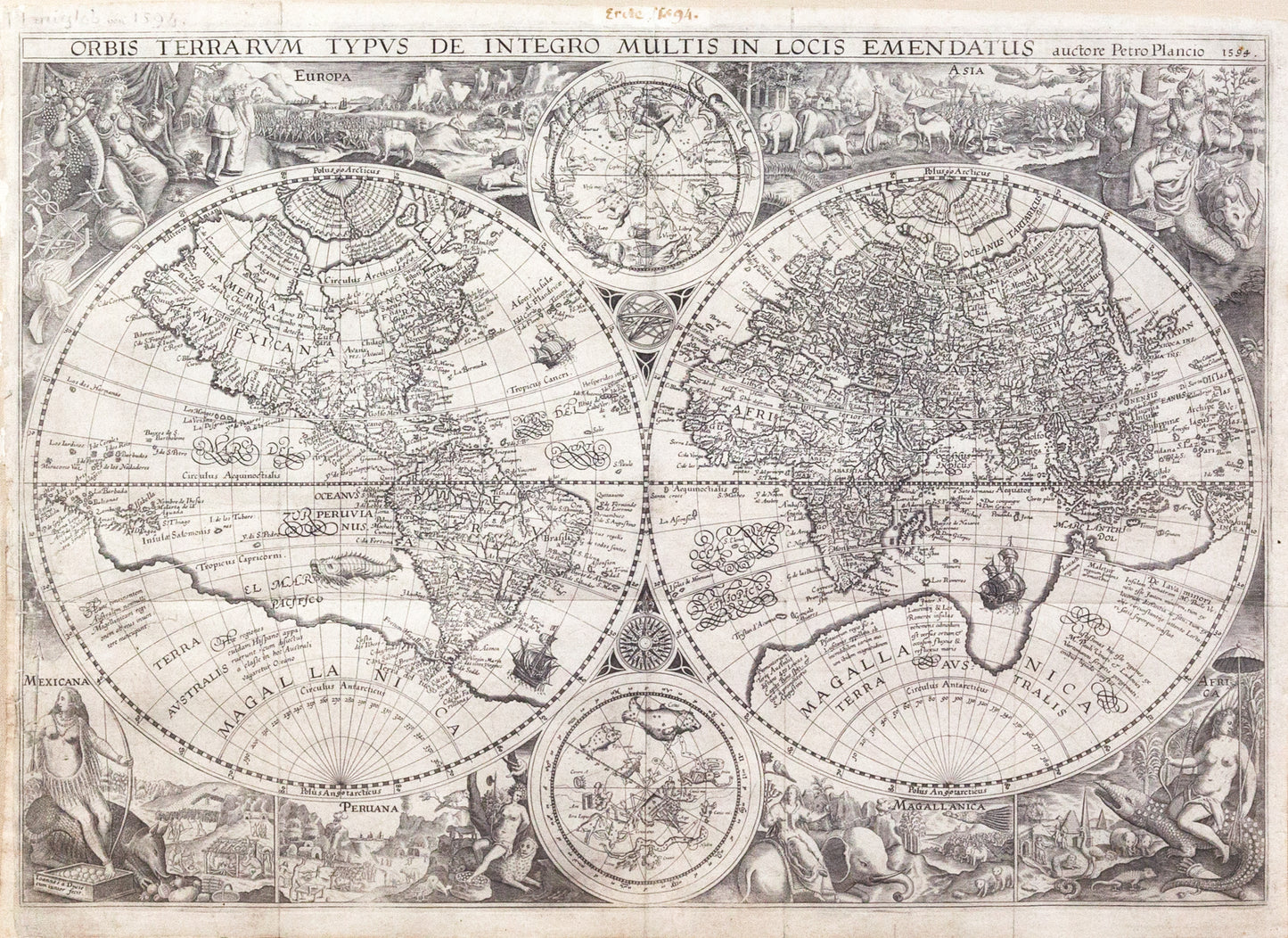
Maps by such cartographers as Ortelius and Mercator were printed in large numbers over long periods of time in part because they were included in atlases. The maps of Petrus Plancius (1552-1622) were different. They appeared in several bibles, one of which was edited by Plancius in his role as a minister of the Reformed Church in Holland, but for the most part they were issued separately in relatively small numbers. That did not mean they were not high quality maps; to the contrary, as this map’s title suggests they offered “improvements in many places.”
Like all Dutch mapmakers, Plancius did not hesitate to build on the cartographic work of others, in this case, on Rumold Mercator’s double hemisphere world map of 1587. His map is to a large extent a copy. He corrected the shape of South America, enhanced details in North America, and revised the mapping of Japan among other changes. He was also among the first to appreciate the value of earlier Portuguese charts, and incorporated information from them into his maps. The quality of his work is reflected in his 1602 appointment as official cartographer to the powerful Dutch East India Company or VOC.
This example was issued separately in 1594 or shortly thereafter, engraved by Jan van Doetecum, a craftsman of great skill whose signature appears in the lower left-hand corner and who was associated with a number of Plancias’ maps. The elaborate pictorial borders are a new addition from the 1590 map, as are the two celestial spheres in the center. The border design was inspired by drawings in the works of Theodore de Bry, whose accounts of explorations in the New World
were published a few years earlier. The regions of the world are symbolized by female figures, and depicted in landscape vignettes and lively pictures of animals indigenous to each. Included are elephants and camels, a giraffe, a unicorn, an ostrich and the footless bird of paradise, parrots, snakes, and monkeys and a rhinoceros, crocodile and a giant armadillo. The borders established a pattern of cartographical decoration that lasted for over a century.
Plancius’s map had a widespread influence on other mapmakers, and is only occasionally available to collectors.
References: Shirley 177.