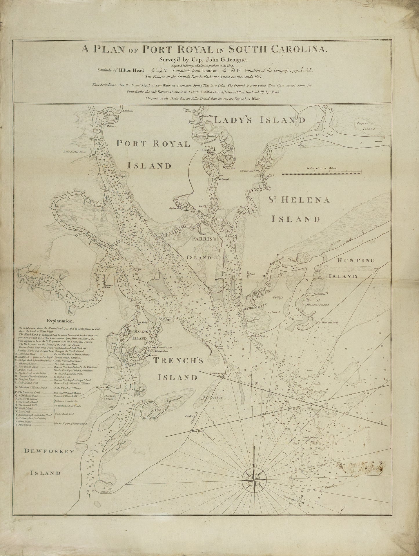
Jeffreys & Faden. A Plan of Port Royal in South Carolina. London, 1776.
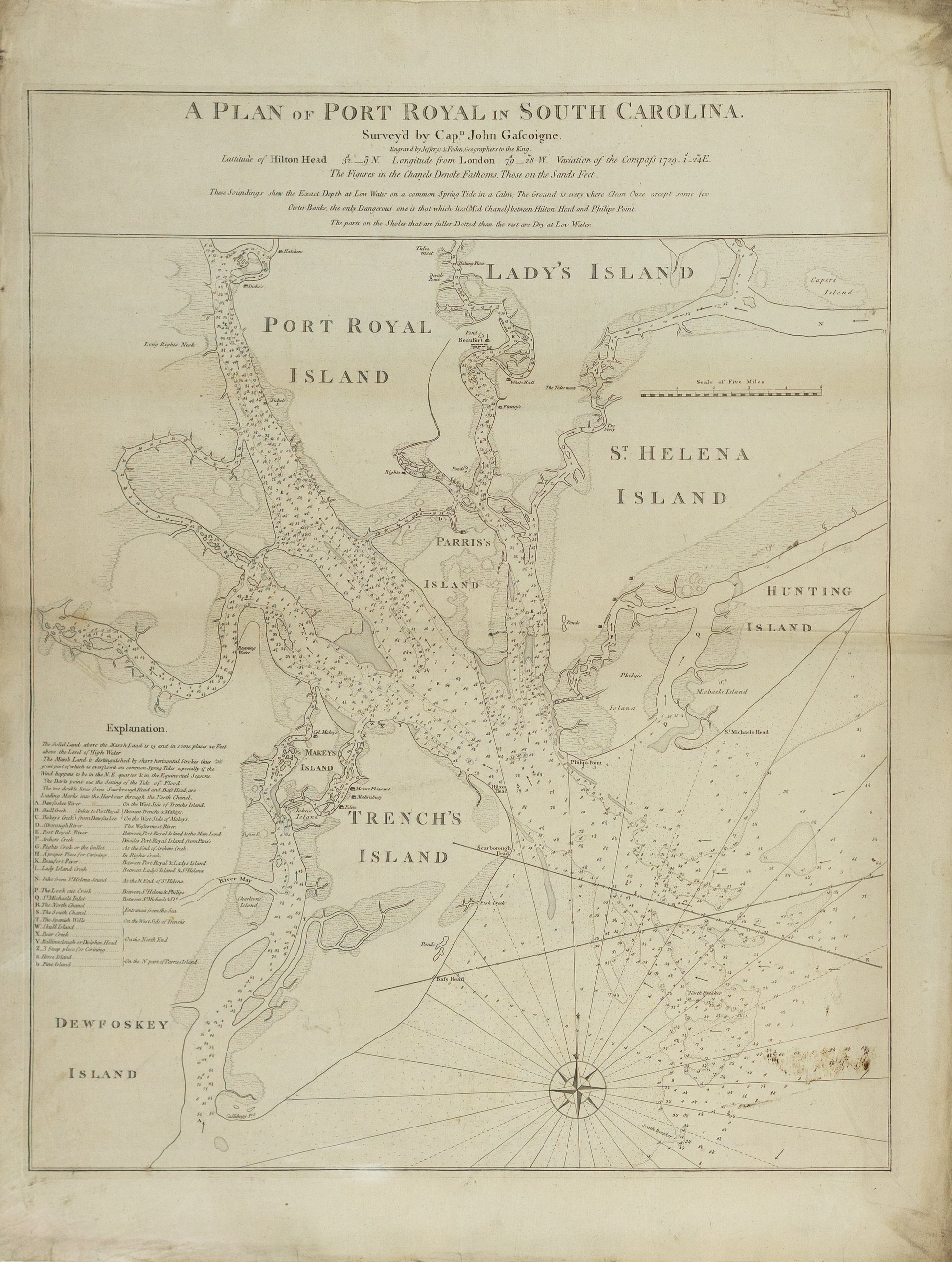
Jeffreys & Faden. A Plan of Port Royal in South Carolina. London, 1776.
Couldn't load pickup availability
Thomas Jeffreys & William Faden
A Plan of Port Royal in South Carolina
London, 1776
33 1/2" x 26 1/2"
The most important charting of South Carolina's Port Royal Sound and Hilton Head, during the early days of the Revolutionary War.
An exceptional chart of the area around Port Royal and Hilton Head, the most important map of this region published prior to American Independence. Gascoigne's chart covers much of the modern Beaufort County. The Broad River enters from the north, and the sound is bordered by Port Royal, Parris, and Trench's (Hilton Head) Island, and Lady's and Saint Helena Islands. Beaufort and numerous plantations are individually labeled.
Gascoigne's chart was one of the most detailed and accurate of any such map of the American coastline. Captain John Gascoigne conducted extensive surveys in the region, assisted by his brother James, in 1728, aboard the HMS Alborough. The next year, this chart was altered by Francis Swaine, whose manuscript chart was ultimately printed by Jefferys and Faden, in 1773, with subsequent editions issued by Sayer & Bennett (1776), Sayer (1791), and Laurie & Whittle (1794).
Gascoigne's chart was the finest and most detailed map available in the early days of the Revolutionary War, and would most certainly have been used by commanders in formulating their battle plans. Early in the war, the region had fallen under the control of the American patriots. However, in December, 1778, the British seized control of nearby Savannah, Georgia. In early 1779, British General Augustin Prevost was determined to further his gains. Taking advantage of Britain's naval superiority, Prevost dispatched the HMS George Germaine and on February 1, 1779, the British first engaged American forces at Hilton Head.
The Americans withdrew up the Broad River, with the British in close pursuit. A fierce battle occurred at Bull's Plantation, forcing the Americans to retreat to the shelter of the surrounding forested swamps. On February 2, 1779, Gardiner decided to attack Beaufort, which was defended by General William Moultrie. Moultrie managed to disable some of the British guns, which neutralized the British advantage. The next day, Gardiner was forced to retreat. On September 24, 1779, at the Battle of Hilton Head, three British ships were set upon by a trio of French ships. After a dramatic chase and intense exchange of cannon fire, the principal British ship, the HMS Experiment, was forced to surrender. The area remained an important base for the American cause, and although the British conducted isolated raids along the coast, it remained in the possession of the American forces until the end of the war.
In 1777, Des Barres published his Plan of Port Royal in South Carolina, likewise based on Gascoigne, and nearly identical to this chart in coverage and content.