GERARD MERCATOR, Asia ex magna orbis terre etc., Amsterdam, 1630.
GERARD MERCATOR, Asia ex magna orbis terre etc., Amsterdam, 1630.
Couldn't load pickup availability
Gerard Mercator
Asia ex magna orbis terre descriptione Gerardi Mercatoris Desumpta studio et industria G.M. Iumioris
Amsterdam, 1630
14 7/8 x 18 3/8 in.
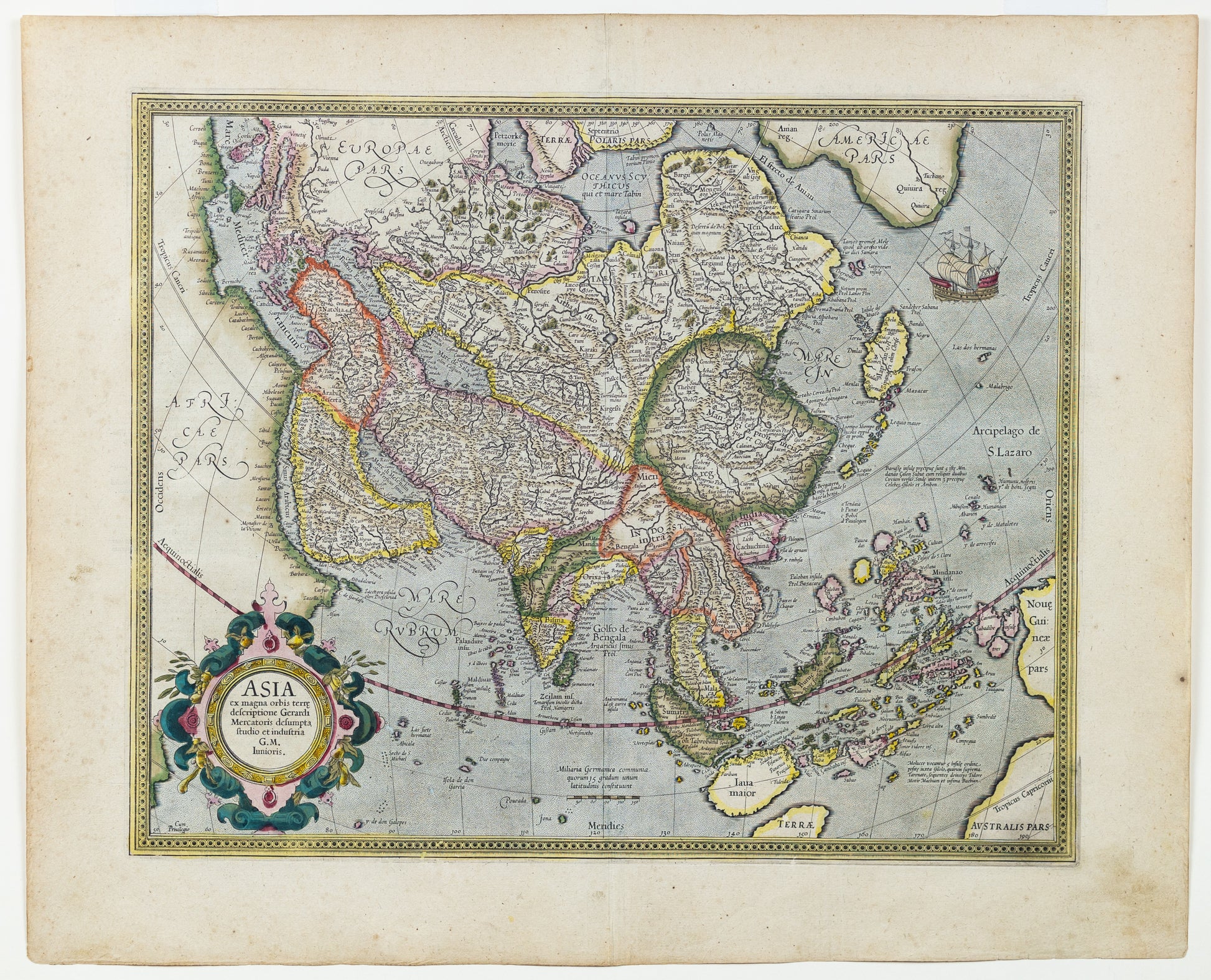
Mercator's map of Asia, in old color, showing the continent in detail and offering a fascinating cartographic snapshot of late-sixteenth century geographic thought.
The centrality of the continent is emphasized in the map’s composition; parts of Europe, Africa, North America, and Australia are all featured. There are also two islands near the North Pole, part of Mercator’s four-island Arctic theory.
Asia itself is thickly blanketed with towns and cities, rivers, mountains, and political entities. Perhaps one of the most interesting details is an absence; Korea is not included here, a reflection of how little was known of the region by Europeans.
Southeast Asia highlights the spice islands, especially the Moluccas, and the rich trade opportunities so valued by Europeans. Farther south, two peninsulas of Terrae Australis Pars loom near the frame of the map. New Guinea is depicted as a large island to the east, incomplete in its outline.
In America there are several place names. Anian is a transfer of a toponym first mentioned by Marco Polo; the nearby Strait of Anian was thought to separate Asia and America. Another place name, Quivira refers to the Seven Cities of Gold sought by the Spanish explorer Francisco Vasquez de Coronado in 1541. In 1539, Coronado wandered over what today is Arizona and New Mexico, eventually heading to what is now Kansas to find the supposedly rich city of Quivira. Although he never found the cities or the gold, the name stuck on maps of southwest North America, wandering from east to west.
The curved projection also features a handsome strapwork cartouche and a large sailing ship.
The map is based on Mercator's celebrated world map of 1569 and was included in his atlas, which debuted in 1595. The map was later updated when the plates were acquired by Jodocus Hondius in 1606. Most notably, he added Korea as an island.
