FADEN & SAUTHIER MAP OF THE PROVIENCE OF NEW YORK, 1776
FADEN & SAUTHIER MAP OF THE PROVIENCE OF NEW YORK, 1776
Regular price
$ 10,000.00 USD
Regular price
Sale price
$ 10,000.00 USD
Unit price
per
Couldn't load pickup availability
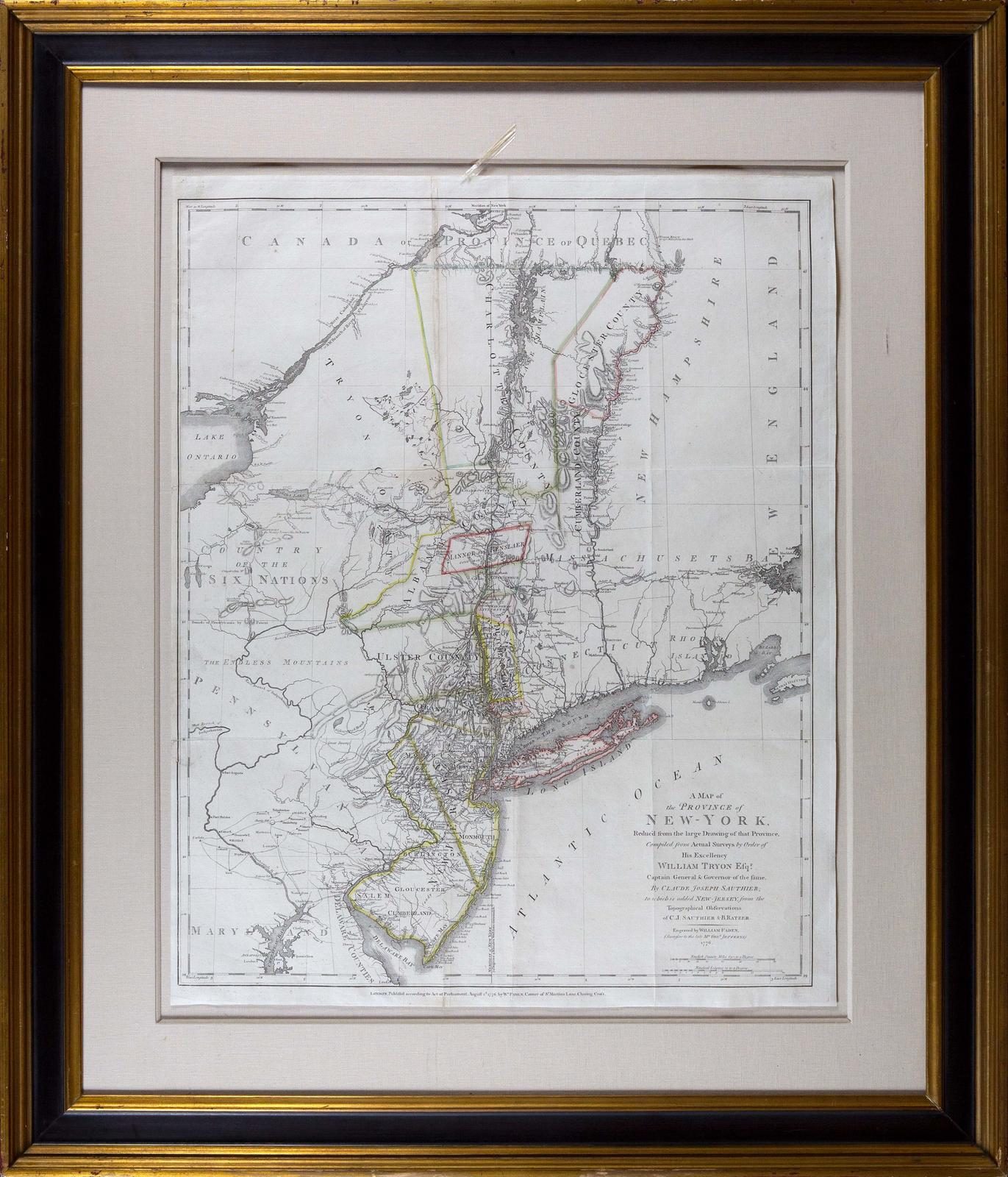
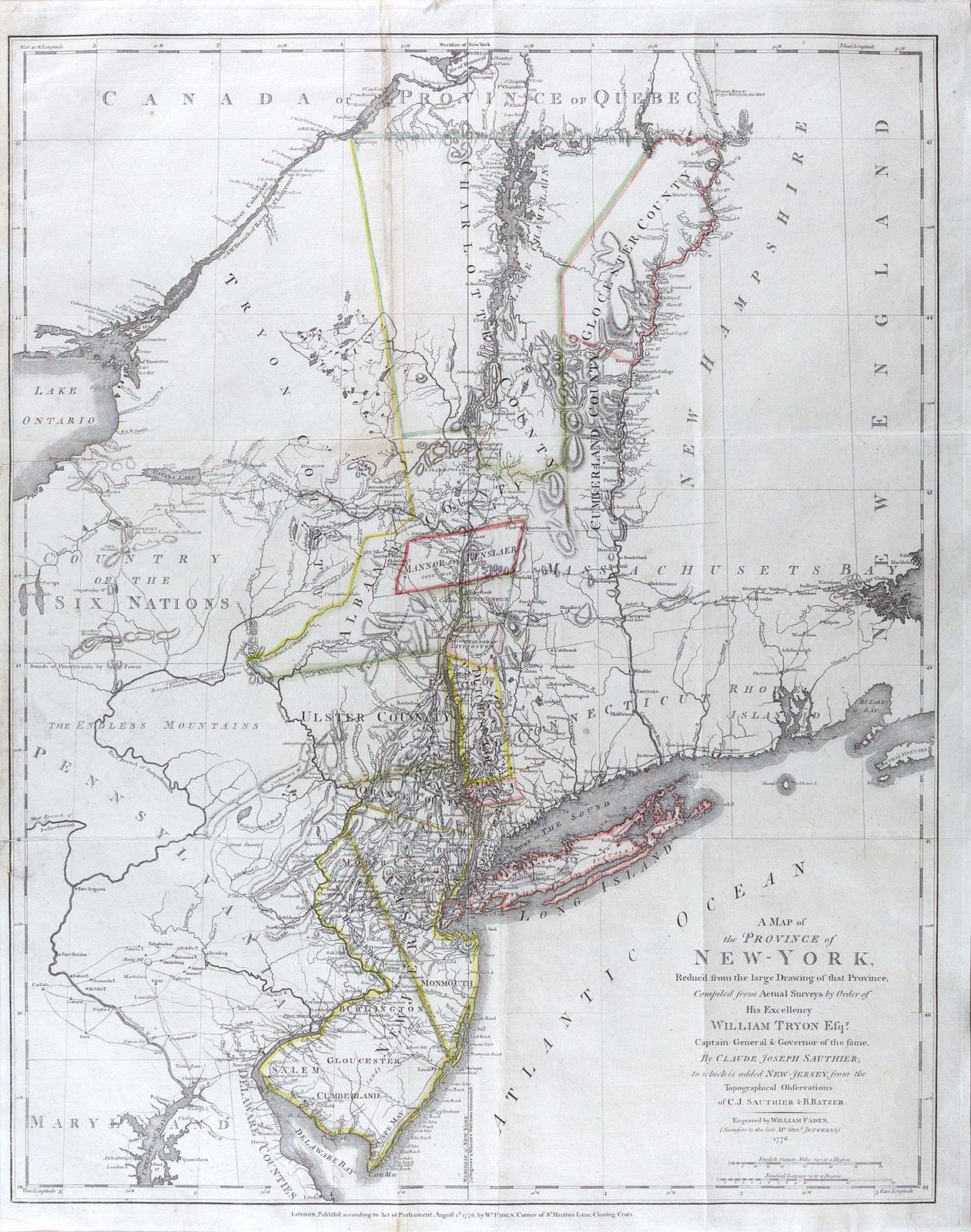
FADEN, William (1749-1836), SAUTHIER, Claude Joseph (1736 1802) & RATZER, Bernard (b. 1700).
A Map of the Province of New-York, reduc'd from the large Drawings of that Province, Complied from Actual Surveys b Order of His Excellency William Tyron Esq....to which is added New-Jersey from the Topographical Observations of C. Gj Sauthier and B. Ratzer.
Copper plate engraving with original hand outline color.
London: William Faden, 1776.
29 1/4" x 23 1/ 2" sheet, 41 ½" x 35 1/4" framed.
Comparable: Swann, 2005 - $9,200; Doyle, 2021 - $5,985.
An important early Revolutionary War era map, published by William Faden shortly after the signing of the Declaration of Independence.
This remarkable map is a combination of two of the most important colonial surveys conducted on the eve of the Revolution, combining Claude Sauthier's manuscript map of New York with Bernard Ratzer's important survey of New Jersey, which established the boundary between the two colonies.
The northern portion of Faden's map is "a reduced-scale (ca. 1:1,050,000) edition of the manuscript version of [Sauthier's] Chorographical Map of the Province of New-York. The extended title of the 1776 edition includes the statement that it is "reduc'd from" a large-scale map by Sauthier." (Allen) Sauthier's map was in turn a compilation of work by Samuel Holland and John Montresor. However, Sauthier's map was significantly more accurate than the maps of its predecessors, proving to be the finest and most accurate maps of New York prior to the close of the Revolution and the standard thereafter for some years to follow.
Unlike Sauthier's map, this map extends south to include New Jersey and the surveys of Bernard Ratzer of 1769, which were undertaken to resolve the boundary dispute between New York and New Jersey. As such, this map pre-dates the publication by Faden of Ratzer's own map of New Jersey, first published in 1777. The boundary between New York and New Jersey is shown with the notation "partition line ordered in 1769." The old boundary between East and West Jersey is also shown.
Although not intended for military use, Faden's map was among the most accurate and useful maps of the region before and after the revolution.
View full details
A Map of the Province of New-York, reduc'd from the large Drawings of that Province, Complied from Actual Surveys b Order of His Excellency William Tyron Esq....to which is added New-Jersey from the Topographical Observations of C. Gj Sauthier and B. Ratzer.
Copper plate engraving with original hand outline color.
London: William Faden, 1776.
29 1/4" x 23 1/ 2" sheet, 41 ½" x 35 1/4" framed.
Comparable: Swann, 2005 - $9,200; Doyle, 2021 - $5,985.
An important early Revolutionary War era map, published by William Faden shortly after the signing of the Declaration of Independence.
This remarkable map is a combination of two of the most important colonial surveys conducted on the eve of the Revolution, combining Claude Sauthier's manuscript map of New York with Bernard Ratzer's important survey of New Jersey, which established the boundary between the two colonies.
The northern portion of Faden's map is "a reduced-scale (ca. 1:1,050,000) edition of the manuscript version of [Sauthier's] Chorographical Map of the Province of New-York. The extended title of the 1776 edition includes the statement that it is "reduc'd from" a large-scale map by Sauthier." (Allen) Sauthier's map was in turn a compilation of work by Samuel Holland and John Montresor. However, Sauthier's map was significantly more accurate than the maps of its predecessors, proving to be the finest and most accurate maps of New York prior to the close of the Revolution and the standard thereafter for some years to follow.
Unlike Sauthier's map, this map extends south to include New Jersey and the surveys of Bernard Ratzer of 1769, which were undertaken to resolve the boundary dispute between New York and New Jersey. As such, this map pre-dates the publication by Faden of Ratzer's own map of New Jersey, first published in 1777. The boundary between New York and New Jersey is shown with the notation "partition line ordered in 1769." The old boundary between East and West Jersey is also shown.
Although not intended for military use, Faden's map was among the most accurate and useful maps of the region before and after the revolution.