Antonio FLORIANUS (1656-1721). [World Map]. 1555
Antonio FLORIANUS (1656-1721). [World Map]. 1555
Couldn't load pickup availability
Antonio FLORIANUS (1656-1721)
[World Map]
Venice, c. 1555
Sheet: 21 1⁄2” x 36”, framed: 33” x 47 1⁄2”
Engraved map
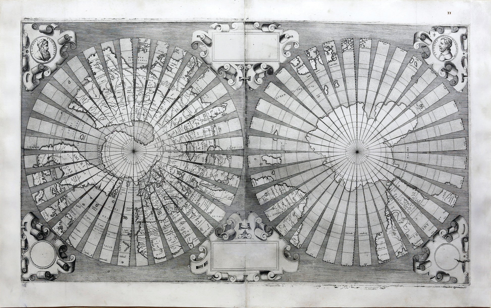
Untitled double-hemisphere map constructed on a polar projections, with each hemisphere cut into thirty-six gores, in the manner of printed globes
John Rennie Short description: “In the early sixteenth century the Venetian Empire was at its greatest extent. It was a trading empire that carried goods throughout the Mediterranean, across Europe and into Asia. The city state became a center of geographic information, mapmaking and cartographic publishing. Venetian cartographers provided the latest geographic knowledge in maps and globes, which became prized possessions for their information and their beauty. This world map is in the form of gores initially designed to be pasted on a sphere, probably made of plaster, to make a globe. This is a wonderful example of the detailed delicate necessary work to make an accurate globe.”
In 1555, the Venetian Senate granted Antonio Floriano of Udine a privilege (the Renaissance equivalent of a copyright) to publish this map of the world. In his application to the Senate, Floriano wrote that he had used his “diligence and knowledge” to create “a mappemonde which has never been made before, with the aid of which one can easily study and learn cosmography and see the entire picture of the world, since it can be reduced to spheric form.” Dramatically, Floriano wrote that the map had caused him “so much drudgery and sweat,” such “heavy toil,” that it defied the imagination. The result of Floriano’s labor was this unique world map, which shows not the eastern and western hemispheres, later one of the most popular formats for world maps, but rather the northern and southern hemispheres, with the earth shown as if bisected at the Equator. In yet another graphic innovation, Floriano divided each hemisphere into thirty-six curving triangular segments meant to imitate globe gores: the sections that, when joined at the edges, generated the spherical form. Floriano’s gores each encompass ten degrees of longitude (hence thirty-six of them, for a total of 360 degrees).
Floriano’s intriguing map bears no title, location or date, and two cartouches at top and bottom that were clearly meant to contain text were left incomplete. Although there is no record of a publication date, Floriano’s petition to the Senate from early 1555 makes it quite likely that the map appeared the same year. Whatever mystery surrounds the exact circumstances of its publication, the map’s refinement is beyond doubt. Floriano’s “mappemonde” is finely engraved and splendidly ornamented. The geographical information was gleaned from Gerard Mercator’s landmark world map of 1538, including the place names as well as forms. The projection, too, was identical to Mercator’s. Floriano shows the Americas as being entirely separate from Asia, and divided into two labeled continents, north and south. A massive sheet of ice occupies the
Arctic, while an enormous landmass covers the South Pole, centuries before the discovery of Antarctica. This example of Floriano’s map is in excellent condition, with handsome examples of decorative strapwork and circular portraits of Ptolemy and Floriano in the top corners. Very few examples of Floriano’s map were issued in the sixteenth century and many fewer survive today. It is legendary for its rarity. This represents a singular opportunity to obtain a striking and unusual map by a prominent Venetian cartographer.
Rodney W. Shirley, The Mapping of the World (London, 1983), n. 99; Rudolfo Gallo, “Antonio Florian and his Mappemonde,” Imago Mundi 6 (1949), 35-38.”
![Antonio FLORIANUS (1656-1721). [World Map]. 1555](http://aradernyc.com/cdn/shop/files/Florianus_WorldMap_GlobeGores.jpg?v=1708720622&width=1445)