
Aaron Arrowsmith. A Map of the United States of North America... (1810).
Aaron Arrowsmith. A Map of the United States of North America... (1810).
Regular price
$ 45,000.00 USD
Regular price
Sale price
$ 45,000.00 USD
Unit price
per
Couldn't load pickup availability
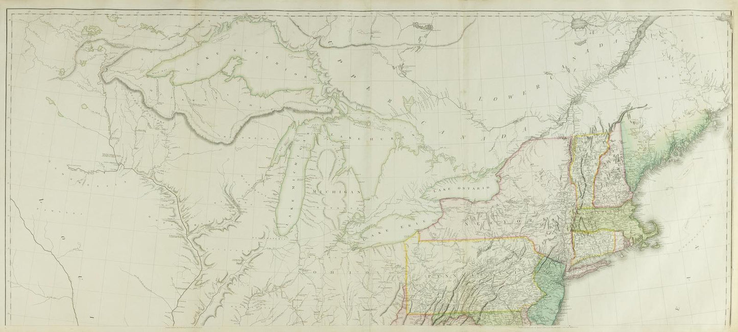
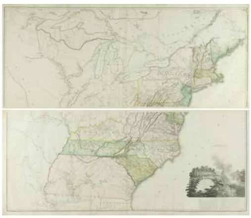
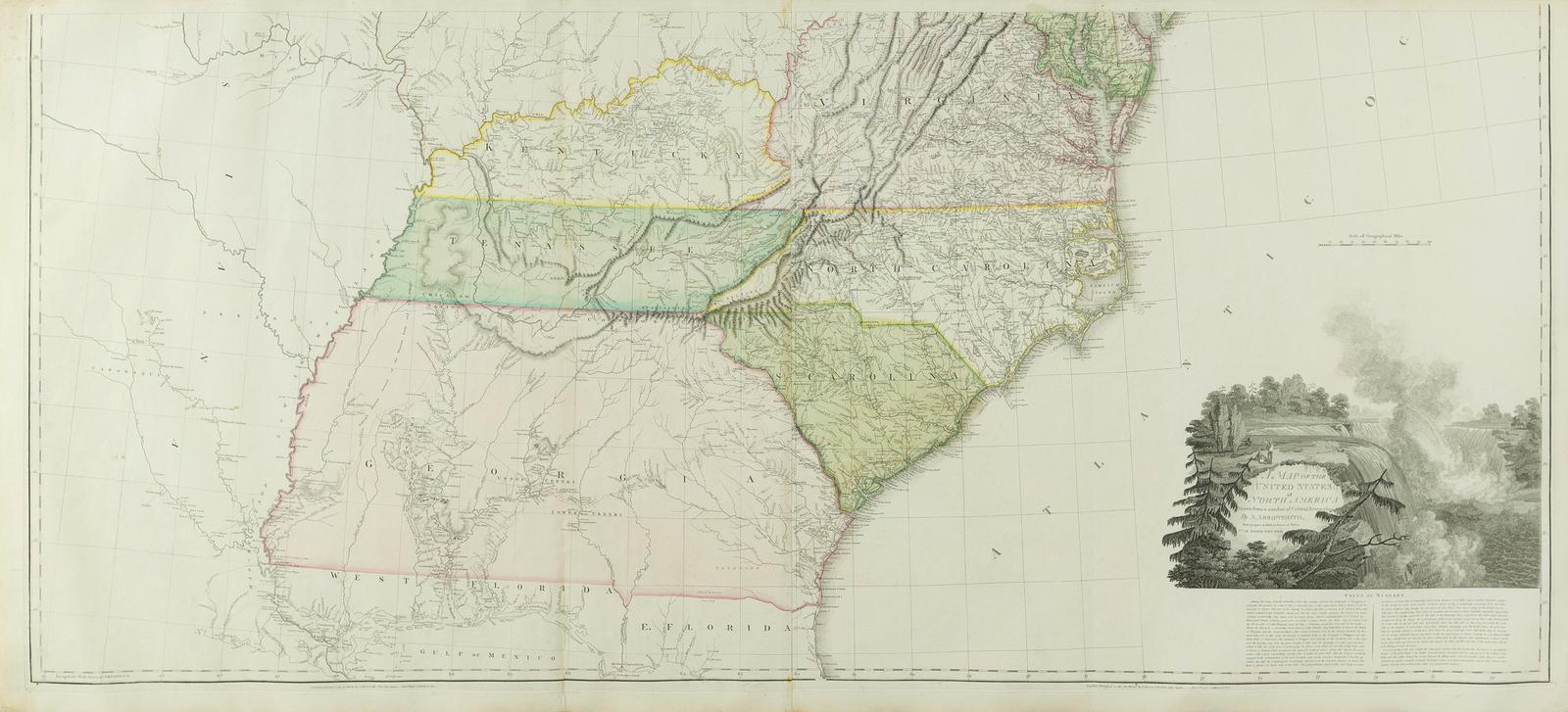
ARROWSMITH, Aaron (1750–1823).
A Map of the United States of North America...
Engraved map with original hand color.
London: Arrowsmith, 1796, Additions to 1802 (1810).
25 1/2" x 57 1/2" sheet, 30" x 62 1/2" framed, each.
Seventh State of the map with the address changed to 10 Soho Square &
Arrowsmith given title 'Hydrographer to H.R.H. the Prince of Wales ... as shown in the cartouche.
Both the 1796 and 1802 versions of Arrowsmith's map served as resources that Nicholas King consulted as he prepared his map for the Lewis and Clark Expedition. Thomas Jefferson owned the 1802 map, purchased at the time of the Louisiana Purchase in 1803.
From 1795 to 1857 at least nineteen editions or revisions of Arrowsmith's map of "North America" were published by him or his successors. On the subsequent third edition of 1815 this map, the Missouri River system is based on Lewis and Clark's published map.
Arrowsmith's 'Map of the United States of North America' is the most desirable from his well noted career. An acclaimed British cartographer, Aaron Arrowsmith drafted accurate, detailed charts that earned him the titles of Hydrographer to the King of England and Geographer to the Prince of Wales, extremely important distinctions during an era when Britain ruled the waves. One of the first great British cartographers of North America, Arrowsmith introduced a new standard of excellence in mapmaking in the late 18th century and almost single-handedly made London the center for the cartographic trade. Arrowsmith built his great success on this ability to attract both commercial and general viewers through his combination of visual and scientific appeal. The most influential and respected map publisher of the late 18th and early 19th centuries, Arrowsmith issued maps that were the result of careful synthesis rather than systematic, scientific inquiry. His role in cartographic production was to gather the best available information from a wide variety of sources, weigh the relative merits of conflicting data, and compile the most accurate depiction possible of an area. Arrowsmith accomplished this synthesis better than any other commercial mapmaker of his day and, as a result, his maps were the most sought after and highly prized on three continents.
References: Tooley: Maps Of America, 172; Stevens & Tree 79(e).
View full details
A Map of the United States of North America...
Engraved map with original hand color.
London: Arrowsmith, 1796, Additions to 1802 (1810).
25 1/2" x 57 1/2" sheet, 30" x 62 1/2" framed, each.
Seventh State of the map with the address changed to 10 Soho Square &
Arrowsmith given title 'Hydrographer to H.R.H. the Prince of Wales ... as shown in the cartouche.
Both the 1796 and 1802 versions of Arrowsmith's map served as resources that Nicholas King consulted as he prepared his map for the Lewis and Clark Expedition. Thomas Jefferson owned the 1802 map, purchased at the time of the Louisiana Purchase in 1803.
From 1795 to 1857 at least nineteen editions or revisions of Arrowsmith's map of "North America" were published by him or his successors. On the subsequent third edition of 1815 this map, the Missouri River system is based on Lewis and Clark's published map.
Arrowsmith's 'Map of the United States of North America' is the most desirable from his well noted career. An acclaimed British cartographer, Aaron Arrowsmith drafted accurate, detailed charts that earned him the titles of Hydrographer to the King of England and Geographer to the Prince of Wales, extremely important distinctions during an era when Britain ruled the waves. One of the first great British cartographers of North America, Arrowsmith introduced a new standard of excellence in mapmaking in the late 18th century and almost single-handedly made London the center for the cartographic trade. Arrowsmith built his great success on this ability to attract both commercial and general viewers through his combination of visual and scientific appeal. The most influential and respected map publisher of the late 18th and early 19th centuries, Arrowsmith issued maps that were the result of careful synthesis rather than systematic, scientific inquiry. His role in cartographic production was to gather the best available information from a wide variety of sources, weigh the relative merits of conflicting data, and compile the most accurate depiction possible of an area. Arrowsmith accomplished this synthesis better than any other commercial mapmaker of his day and, as a result, his maps were the most sought after and highly prized on three continents.
References: Tooley: Maps Of America, 172; Stevens & Tree 79(e).